
“A foreign girl climbing Poroshiri alone? I have lived here 50 years, and the mountain is no joke.” So said the old man at the visitor center in Batori, Hokkaido, giving me a concerned look and shaking his head. Pointing to the sky, he warned there would be a terrible storm the next day, and I should pay heed.
“Long fisherman boots, do you have those?”
“No, but I have sandals,” I said, pointing to the Tevas strapped on my bike rack.
“Young lady, the water level is already pretty high from the rains; this is not a good idea.” Annoyed from his warnings, I said thanks and rode off without waiting for him to say more.
The trail was pleasant-going for the first hour but it soon became clear the old guy was right. I had tried a few tricky maneuvers to avoid the streams, but soon I found myself up to my waist in water, pack high on my back. The clouds appeared heavy, and I was determined to make it to the small mountain hut before the storm.
I arrived just as the rain began to come down and had a feet-drying session along with my dinner. More and more hikers came to the hut, four hours below the peak, with a tour group of 22 hikers the highlight of the evening. Deciding where we’d all sleep was not an issue. If there was a centimeter of available floor space, it was occupied in seconds.

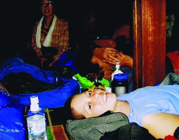
The next morning the wind howled outside, and it was clear no one would reach Poroshiri-dake that day. That night more than 50 people came to the hut, and we slept like sardines. It was all in good fun compared to the night before.
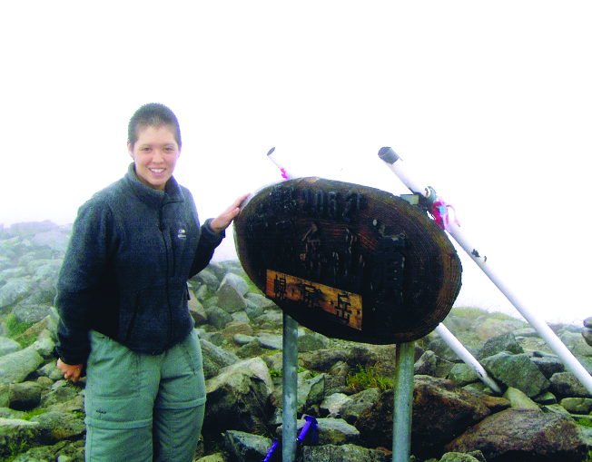
Older ladies were particularly interested in giving me chocolates and goodies. I told them I was here to do the Hyakumeizan and was happy to hear they were doing the same. A lady from Nagoya, who gave me an almond bar, said she was on number 87 and asked about me. Everyone had a big laugh when I replied, “This is number one!”
The next day the weather still wasn’t friendly but, feeling happy inside, I left my gear at the hut, grabbed a liter of water and a few snacks and quickly headed toward the summit. The rain cooled me down, but the wind would pick up, threatening to flatten me on the way back down to the hut. After grabbing my stuff and changing into sandals for the hike back to the trailhead, I wondered if swimming back would be faster than hiking.

Trail Tips
There is only one hut on the trail, so be sure to make a reservation in advance or bring a tent with you and a warm sleeping bag. There are numerous places where you’ll have to cross streams, so bring waterproof boots and a change of socks. Your gear may get wet, depending on rainfall and water levels, so wrap everything you want to keep dry in waterproof bags. Transportation to and from the mountain by bus can be difficult, as they are not frequent, and taxis are expensive. Renting a car from Tomakomai Station is recommended.

Mountain Stats
Mountain: Poroshiri-dake
Difficulty Level: 4 out of 5
Location: Hokkaido (Hidaka mountain range)
Peak: 2,052 meters
Duration: Two-day hike
When to go: July-Late September
How to get there: Fly from Haneda to Sapporo. Take JR local train to Tomakomai and continue on JR to Tomikawa. From there take a bus to Furunai. Grab a taxi to the Rin-do Gate trailhead.
Getting There
Haneda (1 hr. 40 mins. ¥17,000) ► Sapporo (1 hr. 10 mins. ¥1,400) ► Tomakomai (48 mins. ¥900) ► Tomikawa (1 hr. ¥1,270) ► Furunai (1 hr. 10 mins. ¥12,000) ► Rin-do Gate Trailhead
Things to bring
- Waterproof bag for gear
- Raingear
- Flashlight
- Map
- Camera
- Sunscreen
- Water
- Camera
- Gloves
- Sunglasses
- Warm hat
- Food supplies
- Sleeping bag
Contact Information
Poroshiri Sano Lodge: (0145) 73-3141
Machi-tsukuri Information Center: (0145) 72-2221
Things not to miss
Don’t miss hot springs at Family Land Onsen area. It only costs ¥450 to take a dip, and you can try some local fare at the restaurant connected to it. Contact (0145) 72-3280.
Recommended Hiking Schedule
Day 1: 4 hrs.
Day 2: 10 hrs. 50 mins.