What would it feel like to run on the moon? Would you settle for blazing a trail on a live volcano in Tokyo?

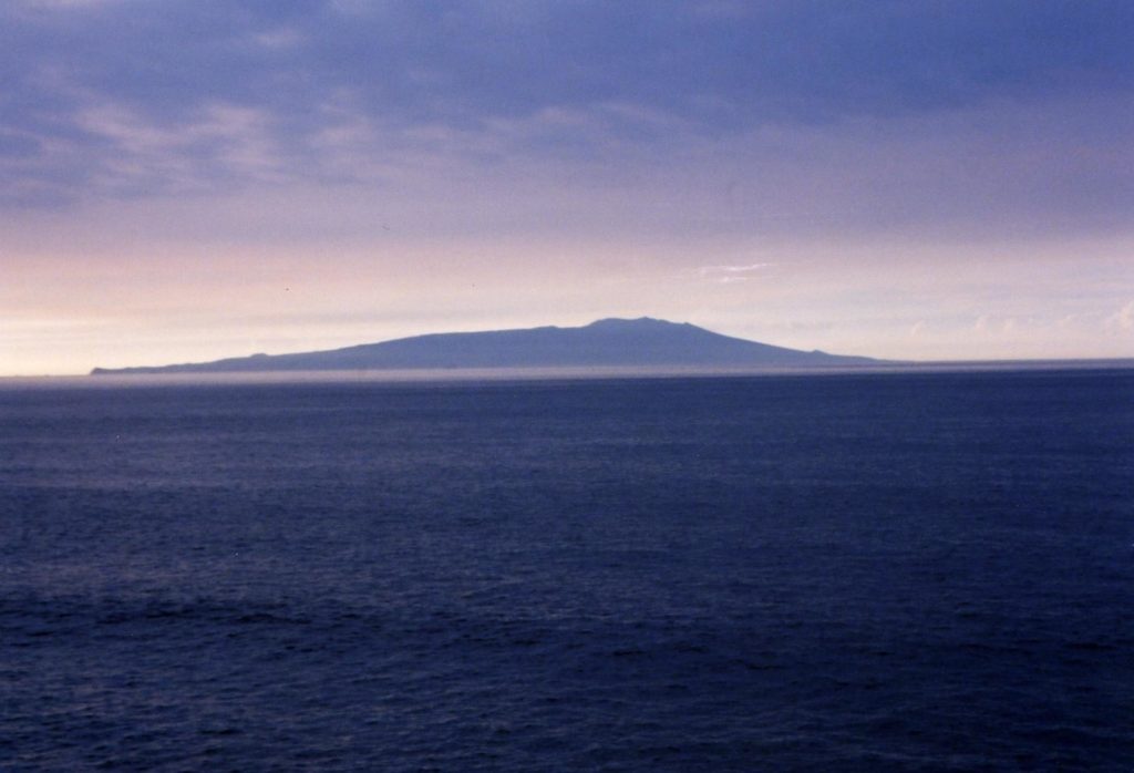
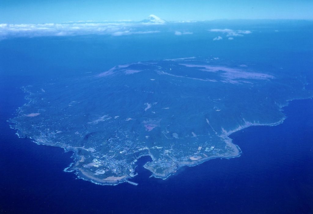
On a clear day, if you are standing on the beach of Sagami Bay, an island rises out in the distance. On a hazy day it is barely visible, yet getting there is a mere one-hour-and-40-minute boat ride. The volcanic island of Oshima is 120 kilometers south of Tokyo. The island is filled with wondrous scenery and astounding trails that will undoubtedly awe and impress even well traveled trail runners.
In order to get a feel for the place, first look at the huge, stark black volcano in the center of the island. The volcanic mountain is called Mihara-yama (764m) or Mt. Mihara, and is the largest on Oshima. It majestically overlooks everything and everyone on the island, like a towering god.
Usually, this serene mountain sleeps peacefully. However, every 35 years or so, it awakens to transform into a ferocious rumbling, red-hot lava-spitting ogre. The most recent eruption was in 1986, and it was big enough that the entire island was completely evacuated. This volcano, one of the most active in the world, is both the creator and destroyer of the distinctive land features and unique trails that crisscross Oshima.

So where should you start exploring? While it’s possible to begin your hike or run from the very bottom of the mountain, most people who visit the island make their way up by bus or taxi to one of two trail heads located near the top of the mountain – the Mihara-Sancho Trail Head and the Mihara-yama Hot Springs Trail Head. From here you can climb to the top of Mihara-yama.

The summit is essentially a central hub from which trails radiate out in all directions toward the ocean. There are many fantastic trails you can explore, but the four introduced here—the Ohachi Meguri, the Omote Sabaku Desert course, the Texas Hiking course, and the beautiful Seaside Nature Trail—are particularly impressive with diverse scenery ranging from black volcanic pyroclastic rock to lush green forests.
Crater Trails
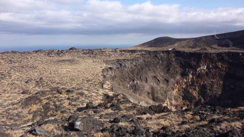
The Ohachi Meguri Trail (approximately 6 kilometers, 2 – 3 hours)
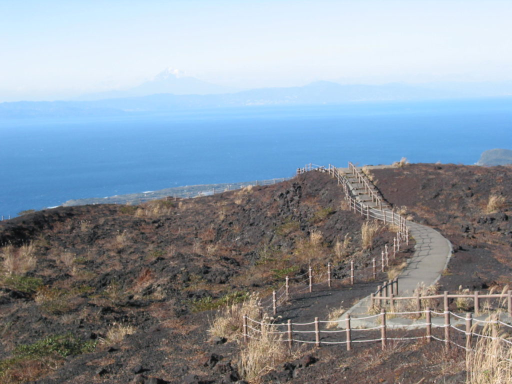
One of the most popular trails on Oshima is the Ohachi Meguri – a short but impressive trail taking you right around the top of Mihara-yama. The easiest way to get there is from the Mihara-yama Trail Head (you can take a bus or taxi up to the trail head). Here you’ll find a cozy tea house (Gojinka Chaya) with superb views of the volcano as well as several gift shops for the tourists who, by the way, come by the busloads. There are washrooms, a rest area with benches, and even a police station here.
From the lookout area, you’ll see a single asphalt road cutting across the barren landscape. The route is simple. Just walk down the hill and take the long, straight road across a lava field. Once you reach the foot of the mountain, the road winds its way up toward the summit. It’s short but steep, so trod slowly, making sure to look back from time to time to check out the incredible vistas below.
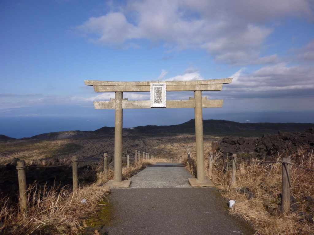
Once you reach the top, in the middle of a cluster of jagged lava formations, you’ll see a Japanese torii – the gateway to the sacred Mihara Shrine. Take the stairs down to the shrine and look around. During the last eruption, molten lava oozed its way down the mountain, destroying everything in sight. Legend has it though, that when the lava reached this shrine, it miraculously parted and flowed around it, thus leaving the shrine intact.
Needless to say, this Mihara Shrine is considered an object of worship by the people of Oshima. From the main trail, make sure you also take the short “detour” route up toward the center of the mountain where you can peer down into the scary, steaming hole of an impressive crater. The Ohachi Meguri Trail is well maintained, making it a relatively easy hike, and the 360-degree panoramic views from the top of this volcano are breathtaking.
Black Desert Running
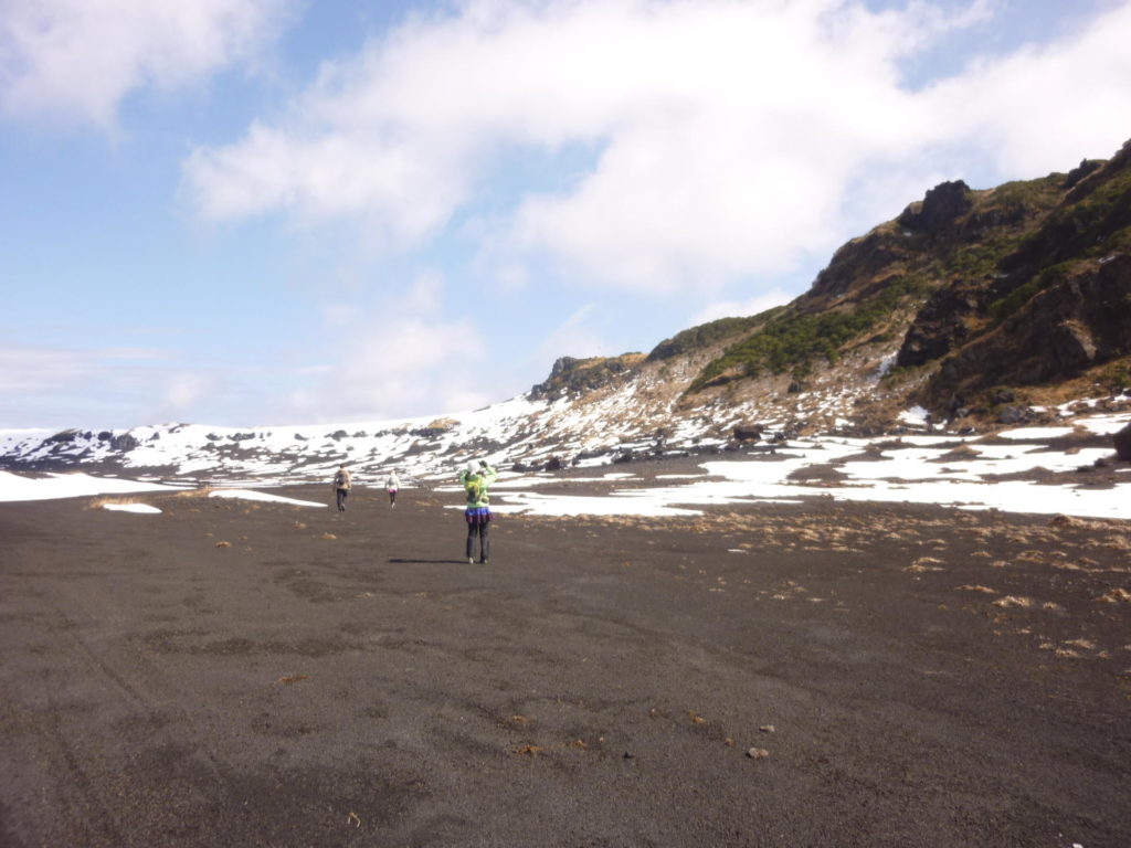
The Omote Sabaku Trail (approximately 7 km, 3 – 5 hours)
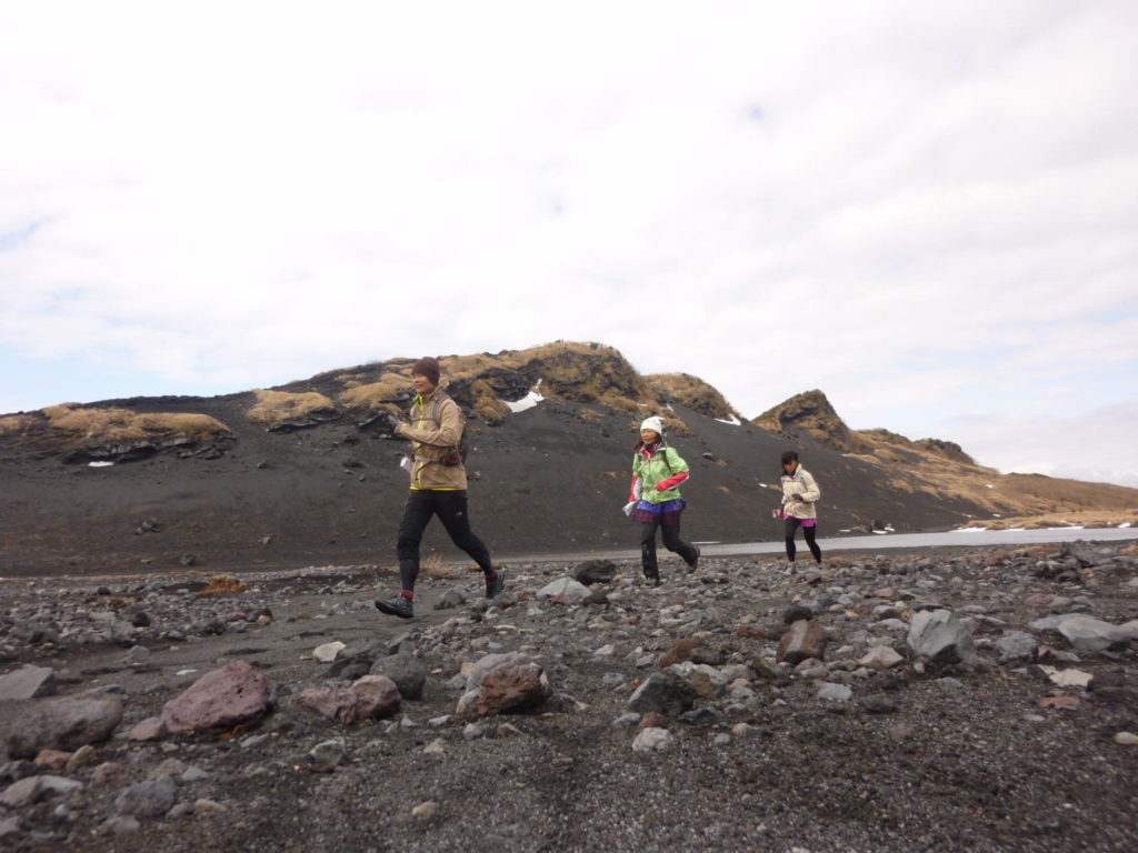
On the south foot of Mihara-yama is an area called “Omote Sabaku” or “front desert.” The most exciting way to reach the trail, in my opinion, is to dash down from the top of Mihara-yama, hollering and whooping in ecstatic delight.
Unlike hard-packed dirt trails, the “trails” here are crumbly granular lava rock, and the trick is to keep your balance while letting your feet comfortably sink and slide with the rocks as you descend. As its name accurately reflects, every which way you look, the land spreads out in front of you like a remote barren desert and, if there’s one word that jumps to mind upon seeing this, it’s “freedom!”
Walking (or running) counter-clockwise around the mountain, you’ll be treated to views of the regal Mihara-yama on your left and the ocean and Izu Islands floating in the horizon on your right. You’ll also pass by an old concrete foundation of a roller slide, a remnant from the 1930s heydays.
Back then, Oshima used to be a busy place, hustling and bustling with people and motorcars. Famous artists and writers, sea-faring sailors, fashionable young ladies and a ton of tourists all flocked to this popular island destination.

One of the main “attractions” other than the volcano was a super long roller slide that zipped you down the mountainside. Certainly a must-do for thrill seekers at the time. Unfortunately, the metal roller slide had to be dismantled during the war when Japan ran into a shortage of steel. So today we’re left with only the concrete foundation and our imagination.
As you make your away along the trail, the unbelievable vastness of it all will make you begin to wonder whether you’re really in Japan…or perhaps on the moon. The sky, the desert, the mountains and, oh, the views. The views!
Summit to Sea
The Texas Trail (Approximately 7 kilometers, 3 – 5 hours)
When a Japanese person imagines what the Lone Star State of Texas is like, perhaps the barren scene here is what comes to mind. Most likely named for its spacious, ranch-like setting, the land near the top is a mountain made of black volcanic rock with not a tree in sight. But the real beauty of this trail is the amazing change you’ll see as you descend from the top of Mihara-yama toward the ocean.
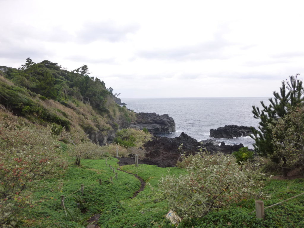
First, you’ll pass through a sea of black lava rock, frozen into weird eye-catching formations for eternity (or at least until the next eruption). As you descend further, you’ll start to see a few hardy looking plants and some low growing shrubbery here and there. The more you descend, the more trees you’ll find, until finally you’ll find yourself running through a beautiful green forest with the sound of the ocean ahead of you.
The trail ends at the Oshima Park where there are more than 10,000 Japanese Camellia trees planted and bright red and pink camellia flowers blooming between the months of January and March. There are not that many trails in the world where you can experience the various ecosystems of an island in one descending swoop, and the dramatic change as you go from the very top of the island all the way down to the sea is fascinating to see and experience.


Seaside Stroll
The Seaside Nature Trail (Approximately 4 kilometers, 1 -2.5 hours) On the northeastern side of the island, there is a lovely Seaside Nature Trail perfect for hiking and trail running. The gently undulating dirt trail takes you over cliffs overlooking the ocean, between rows of Japanese Black Pine, and underneath beautiful camellia tree tunnels. The path darts in and out of the forest, opening up from time to time to reveal the crashing waves below.
Oshima Facts
Oshima, which translates into “Big Island” despite only being nine kilometers wide and 15 kilometers long, is the largest and most populated of a group of islands collectively called Izu Shichito” (or Izu Seven Islands). These islands are in fact officially a part of Tokyo but, as anyone who’s been there will quickly realize, entirely a world away from the busy neon metropolitan.
Oshima is renowned for its beautiful bright red Japanese camellia flowers that blossom in early spring and for its excellent diving spots during the summer. The island’s centerpiece however, is undoubtedly Mihara-yama, the live volcano that sits right smack dab in the middle of the island. In September 2010, the island of Oshima was officially designated as a UNESCO Geopark.
- Total area: 91 km2
- Size: 9 km. east to west, 15 km. north to south
- Circumference: 52 km.
- Population: 8,483 (as at April 1, 2011)
- Highest Point: Mihara-yama, 764 meters
GETTING THERE

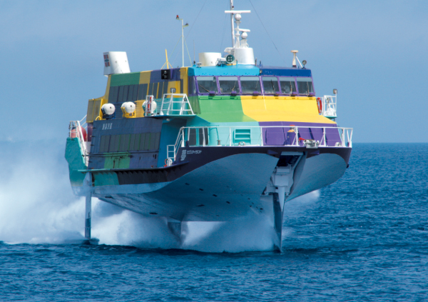
The fastest and most convenient way to get to Oshima is by high-speed jet boat. A slower but cheaper alternative is to take the overnight ferry that leaves Tokyo at night and arrives in Oshima early in the morning. If you want to get there quickly, there are flights from Haneda Airport to Oshima as well.
- High-speed Jet Boat Travel time: 1 hour, 45 minutes Departing from: Takeshiba Sanbashi Pier, Hamamatsucho, Tokyo, as well as Kurihama, Atami, Ito, Tateyama
- Ferry Travel time: Approximately 4 – 6 hours Departing from: Takebashi Sanbashi Pier, Yokohama, and Shimoda See the Tokai Kisen Web site for schedules and fares. Web: www.tokaikisen.co.jp/english/ Tel: 04992-2-5522
- By Plane Travel time: 40 minutes Departing from: Haneda Airport ANA Domestic Flight Reservations Tel: 0570-029-222 Web: www.anawings.co.jp
GETTING AROUND
- Bus Oshima Bus Tel: 04992-2-1822 http://oshima-bus.com
- Taxi Oshima Koutsu Tel: 04992-4-1392 Nagaoka Koutsu Tel: 04992-2-2691
- Car Rental Izu Oshima Car Rentals, Tel: 04992-2-2691 Toyota Rent-a-Lease, Tel: 04992-2-1611 Kaiyou Car Rentals, Tel: 04922-2-2740 Nihon Car Rentals, Tel: 04992-2-3039
- Bicycle Rental Ramble Rental Cycle, Tel: 04992-2-3398 Asami Bike Rentals, Tel: 03992-2-8407
RECOMMENDED ACCOMMODATIONS
- Asami-kan 東京都大島町岡田字助田58-1 Tel: 04992-2-8407 www.asamikan.com
- Izu Oshima Onsen Hotel 東京都大島町泉津字木積場3-5 Tel: 04992-2-1673 Web: www.oshima-onsen.co.jp/index.html
- HOT SPRINGS Opening times vary depending on the season. Please check the hot spring websites for hours of operation.
- Gojinka Hot Springs A spacious hot springs onsen facility with a 25-meter pool and sauna. 東京都大島町元町字仲の原1-8 Tel: 04992-2-0909 Web: www.town.oshima.tokyo.jp/highlight/gojinka.html
- Motomachi Hamanoyu Watch the sunset over the ocean in this open-air hot spring. Bathing suits required. 東京都大島町元町字トンチ畑882 Tel: 04992-2-1446 Web: www.town.oshima.tokyo.jp/highlight/hamanoyu.html
WEB CONNECTION
- Oshima Tourism Association / 大島観光協会
www.izu-oshima.or.jp - Oshima Town Official Site
www.town.oshima.tokyo.jp - Oshima Navi
www.oshima-navi.com - Izu Oshima GeoPark / 伊豆大島ジオパーク
www.izu-oshima.or.jp/geopark/ - Tokyo Islands
www.tokyo-islands.com