
Now that Japan’s hills and mountains have begun shedding their winter coats, it’s time to pull those trail running shoes out of the closet and hit the trails. Japan’s refreshing, colorful spring season is ideal for trail running.
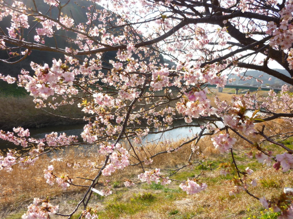
There’s no question early spring in Japan is special, when pink cherry blossoms adorn trees in parks, hills and mountains. The intense beauty is fleeting, however; spring showers or breezes will blow petals from their branches, forming a pink canopy trail runners can enjoy on the trails.
Fresh young flowers and newly sprouting leaves and plants start appearing, and the fresh spring air adds to the trail running bliss. Late spring temperatures are pleasant and generally dry until tsuyu (rainy season) arrives and the summer humidity begins to set in. Here are three fantastic courses to get you moving during this glorious season.
APRIL
Hanami Trail Run
Ogusuyama, Miura Peninsula, Kanagawa
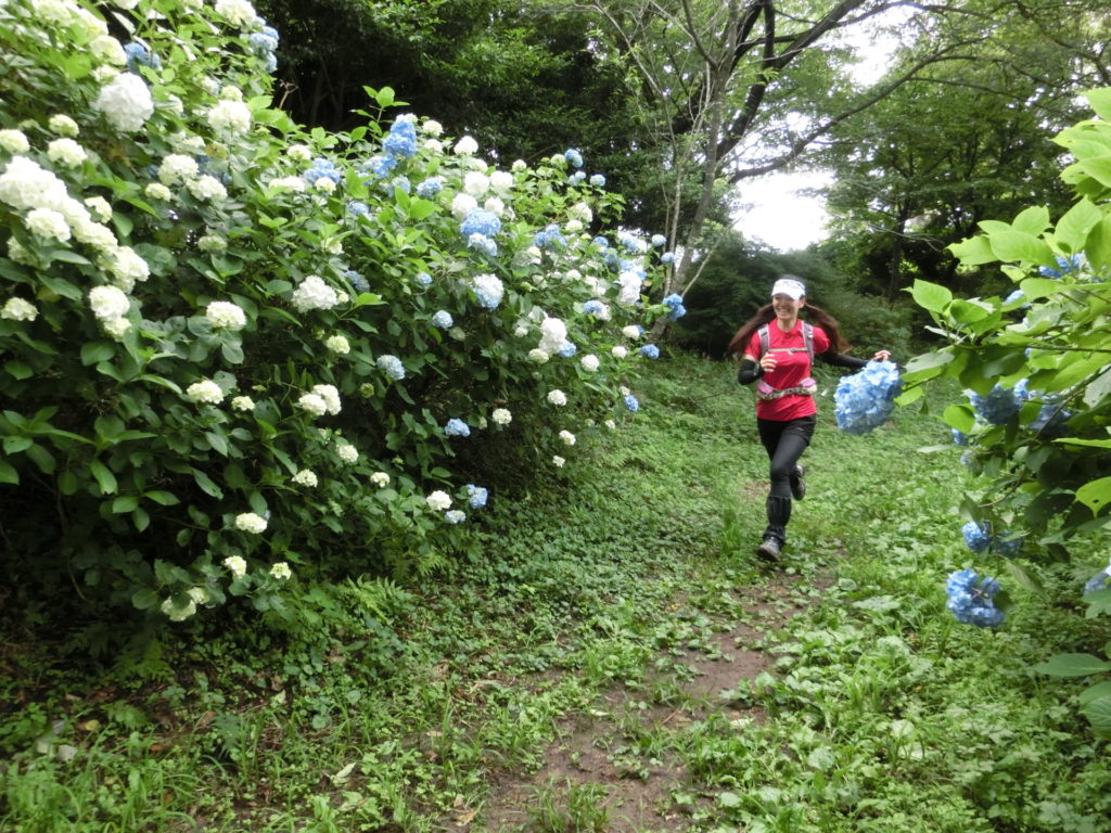
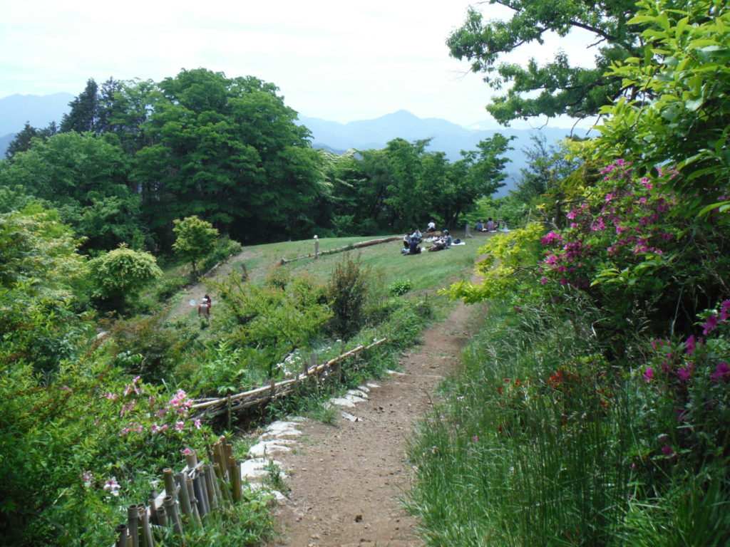
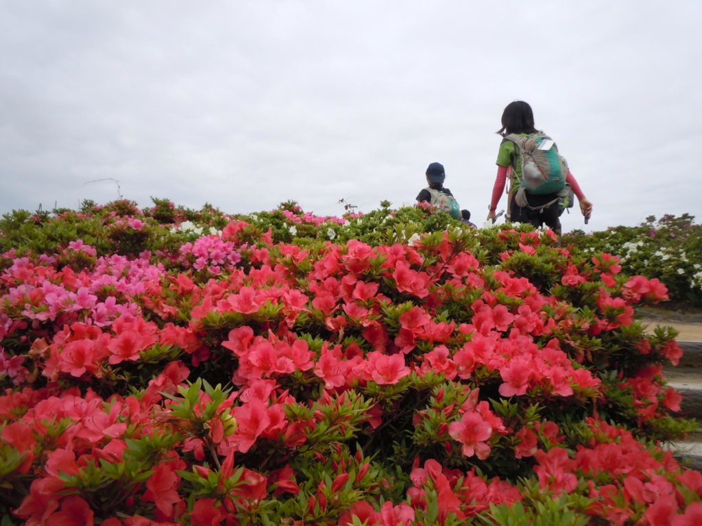
In Japan, hanami (cherry blossom viewing) is one of spring’s most popular and beloved pastimes. These pink-and-white sakura (cherry trees) fill parks and line trails with color as they usher in the season. This hanami course takes you through Kinugasayama Park, which has more than 2,000 cherry trees and is included in the Best 100 Cherry Blossom Viewing Spots in Japan.
It also takes you atop Miura Peninsula’s highest mountain, Ogusuyama — a mere 241.3 meters, but it boasts a magnificent 360-degree view of the Miura Peninsula and beyond.
The Course
Start at Kinugasa Station and follow the signs toward Kinugasayama Park. The Kinugasayama Cherry Blossom Festival is held from the end of March through early April; vendors will have stalls selling food, drinks and trinkets. The beer and yakisoba will be tempting but, beware; overindulgence may result in a fun, but very short trail run.
From Kinugasayama, head toward Kinugasa Jouji. Unfortunately, there’s little left to see of the feudal castle that used to stand here, but it’s a peaceful oasis away from the partying cherry blossom crowds. Follow the signs toward Ogusuyama. You’ll pass vegetable patches, cross a bridge over a busy highway and then run along the outer edge of the Hayama International Country Club golf course.
The final climb to the top of Ogusuyama consists of 230 steps. Your effort and perseverance will be richly rewarded, though, with sweeping views of Sagami Bay and Tokyo Bay. On a clear day, you’ll also be able to see farther out to Izu Peninsula, the Hakone Mountains, Oshima Island, Chiba and, if you’re lucky, Mt. Fuji.
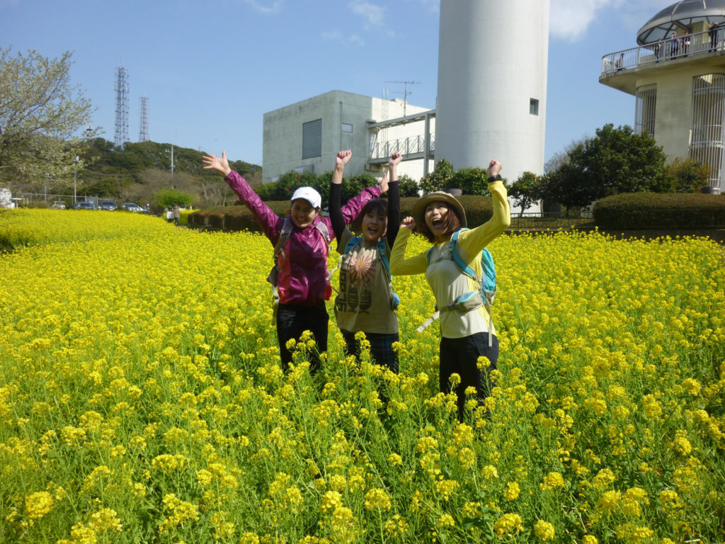
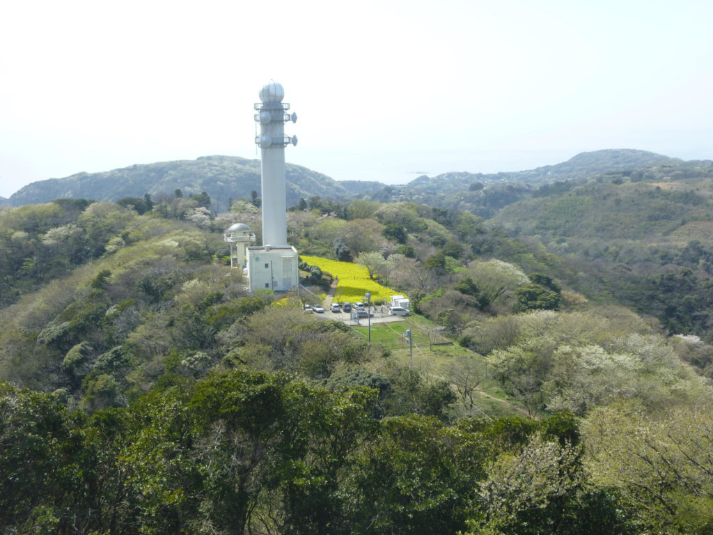
Onwards, follow the signs for the Maedagawa Trail. En route, you’ll pass by an incredibly bright yellow field filled with thousands of fragrant nanohana (field mustard). Like cherry blossoms, nanohana are symbolic of springtime in Japan. It’s also an edible vegetable related to the broccoli family and is sold in supermarkets all over the country in spring.
Jog along the edges of the nanohana field. Take photos of yourself frolicking in the field of yellow. Maybe it’s the intoxicatingly sweet smell of the flowers or perhaps it’s the blinding brightness of it all but, whatever the reason, your heart will be filled with spring joy.
From here, the trail starts to descend toward the Maedagawa (Maeda River). Once you reach the river, the “trail” will become a series of strategically located rocks in the river. This, in my opinion, is one of the highlights of the course.
Hop, step and jump your way across the slowly meandering river. Once you reach the final wooden walkway, you’ll be at the end of the trail. From here, the bus stop for the trip back to JR Zushi train station is just a few minutes away.
Course Info
Start / Finish: Kinugasa Station (JR Yokosuka Line) – approximately an hour and a half from Shinjuku / Maedabashi bus stop (30-minute bus ride to JR Zushi Station).
Distance: Approx. 10 km.
Time: 4–4½ hours
Level: Easy. Recommended for trail runners just coming out of hibernation as well as for beginners.
MAY
Shinryoku Trail Run
Mt. Takao, Tokyo
The word shinryoku consists of two Japanese characters: 新 (shin), which means new and 緑 (midori) which means green. As the characters suggest, shinryoku is a word often used to describe the fresh green leaves that sprout in spring. If you’re looking for a place to immerse yourself in this new green, Mt. Takao is a good place to start.
The Course
There are numerous ways to get to the top of Mt. Takao. You can run or walk up one of the six routes from Takaosanguchi Station, but one of my favorite ways is to hop on the slow but scenic “Eco Chairlift.” The lift only takes you part way up the mountain but is a great way to get in a bit of obligatory sightseeing of this Michelin 3-star rated mountain as you walk along the main “Omotensando” route.
Be forewarned, though. On weekends, and even some weekdays, the top of Mt. Takao can be crowded. Very crowded. If you start to feel claustrophobic, quickly run down the stone steps and head in the direction of Shiroyama and Kagenobuyama. While you’ll still likely be sharing the trail with other hikers and trail runners, you’ll be relieved to find the crowds thinning and will find the peace and quiet for which you’ve been looking.
During April, the cherry blossoms along the trail are lovely. But the reason I’m recommending this route is not for the blossoms, but for the latter half of the course, a continuous soft dirt single track surrounded on all sides by lush green foliage.
From Shiroyama, many trail runners continue northwestward toward Kagenobuyama and Jimbasan. Nice, but not spectacular. I recommend heading south. Take the route that descends toward Odarumi-touge. There’s some seriously prime trail running in this short but, oh so sweet, section.
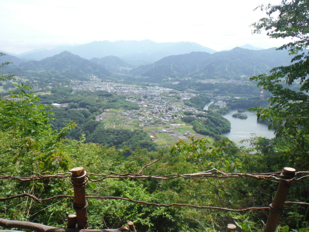
At Odarumi-touge, take the overpass across busy Route 20 (Koushukaidou Road). This is the entrance of shinryoku heaven with beautiful tunnels of green foliage and delightfully runnable single-track trails and, from time to time, peak-a-boo lookouts with jaw-dropping views of the valley below.
The trail, called the Minami Takao Trail, will take you over several small peaks (such as Oborayama and Kompirayama), as well as a few passes (Nakazawa-touge, Nishiyama-touge, Mitsuzawa-touge, Kusato-touge). It’s relatively well marked (albeit in Japanese) and will eventually take you back to Takaosanguchi Station. Remember to bring a map and compass, just in case.
Course Info
Start / Finish: Takaosanguchi Station (Keio Line) – approximately 1 hour from Shinjuku
Distance: Approx. 14 km.
Time: 5-6 hours
Level: Intermediate. Although relatively short, there are numerous climbs and descents along the way. For beginners, it might be better to do an out-and-back route from Mt. Takao.
JUNE
Pre-tsuyu Trail Run
Mt. Tounodake, Kanagawa
The month of June in Japan is known for the onset of tsuyu (rainy season), which essentially signals the end of spring (and the beginning of a very hot and humid summer). Running in the rain can be fun, but let’s be honest, beautiful sunny skies are better. Tsuyu usually happens some time after mid-June, so it might be a good idea to squeeze in a few solid spring trail runs before the rain. The “Omoteone” course will take you high into the Tanzawa Mountains and is a fabulous course, especially on a nice sunny late-spring day.
The Course
To get to the trailhead, catch a bus from Hadano train station. The buses don’t run often, so be sure to check the bus schedules beforehand. After a long and very windy road up the mountain, get off at the Yabitsu-touge bus stop. Walk for about a kilometer along the paved road toward the Fujimisansou (Fujimi Hut).
Across the street from the hut is the path that will lead you to the trailhead for the Omoteone trail, the most popular hiking route in Tanzawa. There will be plenty of signs in both Japanese and English to point you toward your main destination, Mt. Tounodake.
The first half of the course consists of a lot of climbing. Make your way upward through a forest, up some wooden stairs and then up a steep rocky mountainside. Along the way, you’ll pass several small peaks, Ninotou and Sannotou, with wooden benches. Sit and relax, eat some lunch, but then get quickly on your way, because there’s still a long way to go.
After Sannotou comes the undulating ridge section and several thrilling chain sections. While it’s possible to run along the ridges, slow down and be extra careful along the narrow sections. Hold onto the chains embedded into the mountainside when scrambling up/down the rocks. The total climb should take you about three-to-four hours.
The top of Mt. Tounodake (1,490 meters) boasts some fantastic views. There are rows and rows of benches on which to stretch out, and you can buy drinks (albeit expensive) and use the washroom at the Sonbutsu Sansou hut located on top of the mountain. As this is quite a long hike, many hikers will stay overnight at the hut.
After the long climb, you may feel compelled to stay the night as well, however, as an ambitious day trail runner – downward and onward you go. The route down is called Okura-one (Okura Ridge) and is very simple. Just keep running straight down and down and down for about two hours. It’s a quad-busting but exhilarating run. The route ends at Okura where you can take the bus back to Shibusawa train station.
Course Info
Start: Yabitsu-touge bus stop (buses leave from Odakyu Line Hadano train station)
Finish: Okura bus stop (buses go to Odakyu Line Shibusawa train station)
Distance: Approx. 14 km.
Time: 5½-7 hours
Level: Intermediate/Advanced. While relatively short in distance, the course has several big climbs with a cumulative altitude gain of more than 1,100 meters and one very long descent. Recommended for experienced trail runners.