The mountain of the day was Kaimon-dake, also known as Satsuma-Fuji, the symbol of Satsuma-hanto Peninsula. I had less than two hours of shut-eye but was more than happy to start my day and flee from the roach-infested nightmare of a room in Ibusuki.

At breakfast I sat down and pulled out my maps over a cup of a coffee when Mrs. Sato, a middle-aged lady in a flamboyant outfit, started conversation. She wanted to know where I was heading and offered to drive me to the trailhead of Kaimon-dake in exchange for accompanying her to a flower park nearby.
At the trailhead of Mt. Kaimon, I got out of the car and thanked her. As I grabbed my back pack from her trunk, she looked at me hesitantly and asked if I thought she would be able to climb the mountain. I looked down at her purple lace-up tennis shoes and her big leather purse and smiled. The suggested trail-time was four hours, and I couldn’t deny the excitement in her eyes.
On the trail, Mrs. Sato turned out to be somewhat of an expert on flowers and vegetation. Kaimon is a flower-lover’s paradise. We would stop every few minutes or so, and she would give me a mini-lecture on one of the many types of flowers that grow on the mountain. And the entire time she would pick ripe wild strawberries and give them to me to devour.
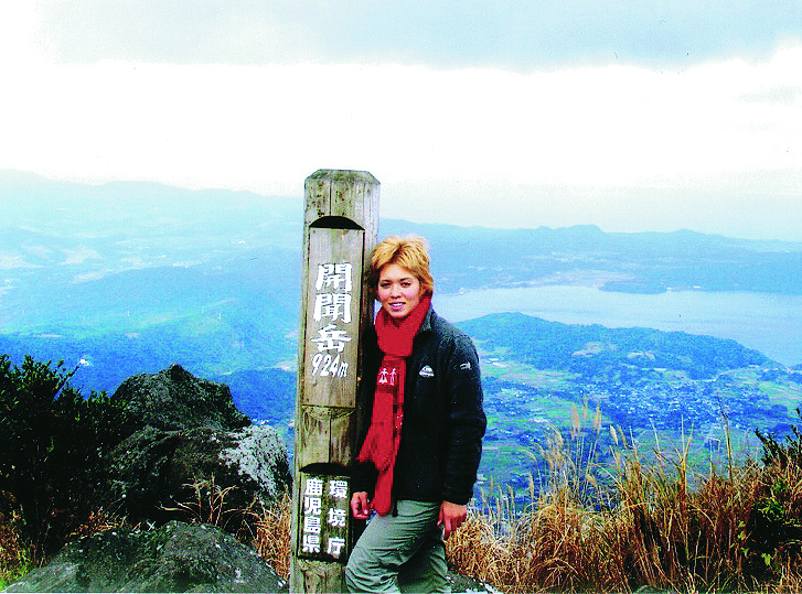
The heat, along with the pestering insects and distance, made Mrs. Sato question if it was really a good idea to be attempting a hike, but we only had a few hundred meters left to the highest point. I grabbed her bag, and we walked arm-and-arm to the summit. It was a gorgeous day, and we could see views of the ocean, the town of Kaimon and the islands of Yakushima and Tanegashima.
Trail Tips
This hike is very easy-going and consists of nine stages starting from 160 meters. The east-side trailhead of Mt. Kaimon is rarely used, so I suggest entering from the parking lot of Kaimon Furiai Park. On rainy days, the boulders from the fifth stage get very slippery, so watch your step. It’s a good idea to start descending by 3 p.m., as the thick forest at the bottom can make visibility poor as evening approaches.
MOUNTAIN STATS
Mountain: Kaimon-dake
Difficulty Level: 1 out of 5
Location: Kaimon-machi, Kagoshima
Peak: 922 meters
Duration: Day hike
When to go: April-December
Things to bring: Raingear, flashlight, map, camera, sunscreen, water, camera, gloves, sunglasses, hat, bug repellent.
Getting There
Fly from Haneda Airport to Kagoshima Airport. Transfer to local bus bound for Ibusuki and get off there. Get on the Ibusuki-Makurazaki Train Line for six minutes and get off at Yamakawa Station. From there, take a taxi to Kaimon-dake trailhead.
Haneda Airport ⇒ Kagoshima Airport ⇒ Ibusuki Station ⇒Yama-kawa Station⇒ Kaimon-dake trailhead
(100 mins. ¥21,500) ⇒ (105 mins. ¥2,100) ⇒ (6 mins. ¥200) ⇒ (20 mins. ¥3,000)
Contact Information
Kaimon Town Tourist Information: (0993) 32-3111
Yamakawa Taxi Service: (0993) 32-3121
JR Bus: (0993) 34-0957
Things Not to Miss
Near the town of Ibusuki is Lake Ikeda-ko, the largest lake in Kyushu. It is a crater lake, formed by the eruption of Mt. Kaimon.
Flower Park Kagoshima has more than 400,000 plants, and you can view seasonal flowers and try teas and snacks made of hibiscus.
Recommended Hiking Time
4 hours, 40 minutes.